| Snow Expected Tuesday across Wisconsin |
By Justin Poublon
January 8, 2024 - 7:15 AM CST |
 1,039
1,039  0
0UPDATE 7:11AM MON - Over the last 24 hours models have settled down over southeast Wisconsin aided by a slight southward trend in the low track. My original pessimism over southeast Wisconsin has faded. I feel like 6-9" is likely across southern Wisconsin. Will try to update the snowfall map later today.
ORIGINAL POST - Hey all! Winter looks to make a return to Wisconsin on Tuesday with the first large snowstorm of the winter. Several inches of snow is expected by early Wednesday morning. In addition to the snow, gusty winds up to 35 mph are possible.
Here are my thoughts on the upcoming system - these are just my opinion's given years of experience. It's been a few years since I've written one of these but here it goes!
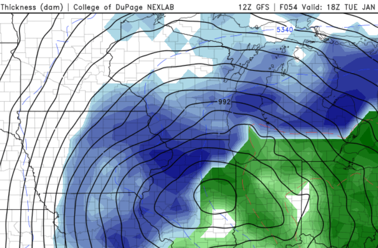
GFS model simulation for noon on Tuesday with snow developing across Wisconsin.
HIGH LEVEL - On Tuesday a mature sub-980mb low pressure system will track over the southern tip of Lake Michigan/Michigan on a northeasterly course through the Great Lakes. It will begin to occlude and drift towards the east on Wednesday. Forecast models continue to dance and there are several factors lowering the overall confidence/impact. Models have been trending northwest on recent runs to center the heaviest snows in Wisconsin however confidence on exact placement of heaviest amounts remains low, per usual.
Several additional factors lower my confidence about this system; 1. the mature nature of the system while sounding strong actually means snow producing features of the system can get disjointed as the system starts weakening. 2. Moisture support is lacking. I'm worried the snow could be gappy with lulls; which lowers the overall impact and snow amounts. 3. Time of peak accumulation will be during the day when temperature profiles in the southeast 1/3 of Wisconsin are near or above 32F during the event - favors lower snow ratios; an uphill battle.
PREDICTION - 12zGFS/00EC are generally in step with a similar prediction while the NAM remains an outlier. The NAM solution is certainly within the realm of possibility given the history of the forecast on this system. I'm leaning towards a central or even western Wisconsin centered event where you'll find cooler surface temps and more favorable mid-level low profiles. I'm expecting periods of heavy snow on Tuesday coming to an end Tuesday night with maybe a lull or two in between higher rates of accumulation. Models support 4-8" of snow in the sweet spot - right now along an axis from southern WI, through central WI, tailing off in NE Wisconsin.
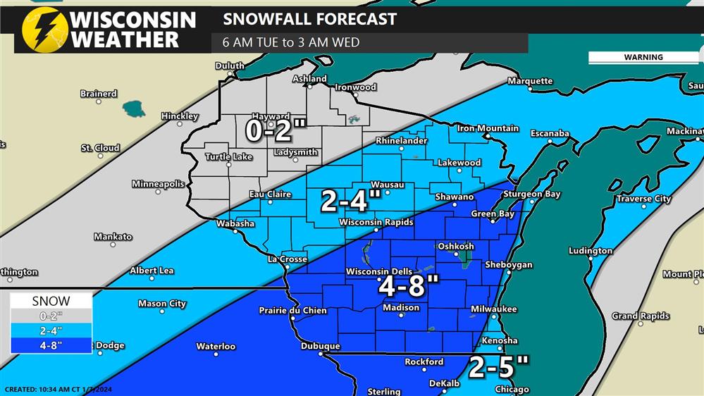
Snow forecast prediction created at 10:30am on Sunday 1/7
This could be situation that falls into northern Wisconsin's lap too. We are still 2+ days away so much can change.
SOUTHEAST WI - Given the time of day, track of the low, and temperature profiles, thinking Milwaukee/Chicago and extreme southeast WI lakeshore communities will end up with a few inches of wet snow. Most models take the surface low right overtop this area with large amount of QPF. It rarely happens like that; you can get high QPF but snow ratios are generally poor. Typically we see the heaviest snows a bit further NW of the low surface low track. Southeast Wisconsin is on bust watch.
WINDS - Windy conditions will develop on Tuesday with gusts in the 25-35mph range. Wind direction will shift during the event, starting out of the north and rotating around to the west by Tuesday night. I don't expect blowing snow to be a huge impact due to wetter snow.
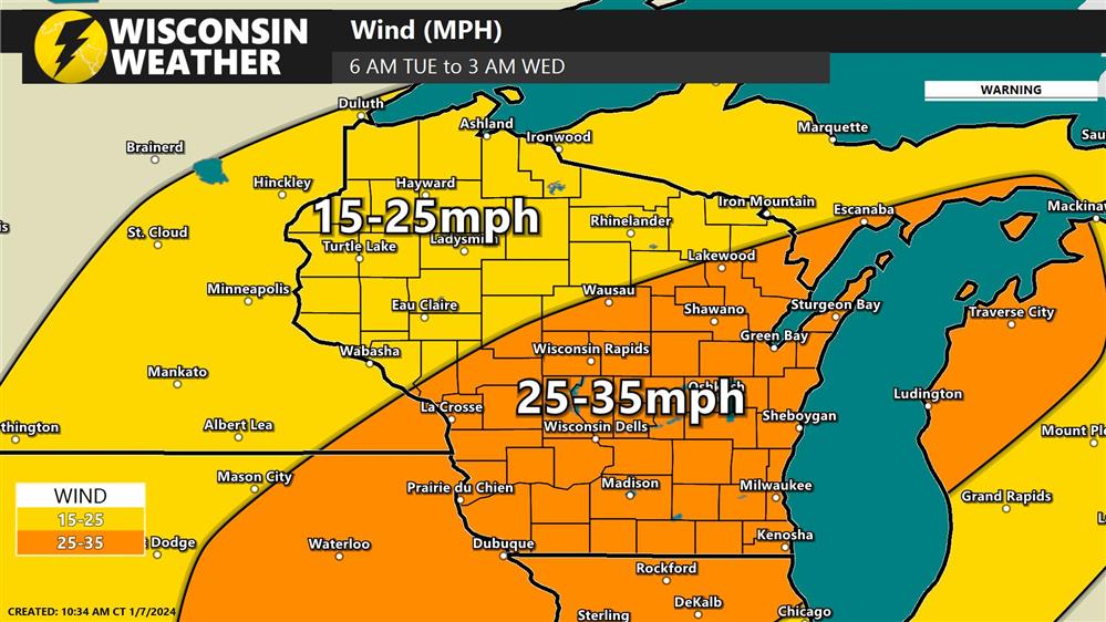
Max Wind gust forecast for Tuesday/Tuesday night created at 10:30am on Sunday 1/7
UPDATE SCHEDULE - I'm not sure I can update this story as new information comes in prior to the event but you're welcome to check back :)