TUES 11:00PM - most recent storm update covers it pretty well. Felt short range models were showing this but I got tunnel vision on previous ideas. EC nailed the heaviest snow location. Short range models today handled situation the best overall.
TUE 11:35 AM
Looking at 12z models (+00z EC), period of moderate to heavy snow will sweep through southern WI tonight (lighter rates north). Start time around 3PM near Dubuque, IA...5-7PM eastern WI. Ending early WED AM.
I feel comfortable with the 4-7" zone across southern Wisconsin. Little doubt at least 4" will fall south of La Crosse - Wi Rapids - Green Bay line. It will fall fast and efficiently. Many places look to receive around 6" in southern WI. GFS has been a bit inconsistent but I do like the broad 5-7" amts progged in the...not showing any heavier amts like the NAM. The NAM has been too snowy w/ recent events however it's been good on placement of the heaviest snows. I really like a blend between GFS/NAM for this event. EC is similar to the NAM. NAM shows a sleet mix approaching the WI/IL border towards the end of the event.
Debated removal of the 7-10" zone in SW WI but decided to leave it & trim it down. Question was "what region is most likely to exceed 7 inches". This is your answer.
In the north; 2-4" consistent through all models. Could see 5" to the west in Minnesota. Not willing to add additional zone just for MN. Also some models have a zone of lesser amounts (1-3") through Eau Claire to Rhinelander.
Posted a blog containing additional info. Will go live this aft. Thanks
MON 10:19 PM - Updated snow map, boosting snow totals north. I felt the 00z run helped. Want to avoid higher amounts of NAM & short range models. Crazy how widespread this event will be - from arrowhead of Minnesota to northern Illinois. Planning a full update tomorrow sometime. Want to put together blog post if time allows.
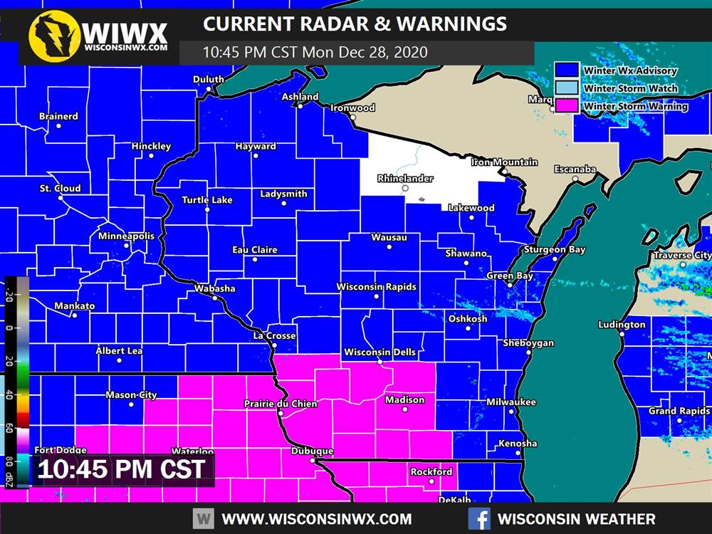
Looks like fun! Most of Wisconsin under an advisory or warning for snow tomorrow night. Sorry Rhinelander!
MON 2:34PM - 18z NAM trended south with heaviest snow, closer to EC. Adjusted snowfall map.
MON 2:07PM - Based on 12Z guidance and recent trends, looking at widespread accumulating snow for Wisconsin. Most places will receive at least *something*, many of us much more than that. In terms of consistency between models, overall track and evolution they all agree. The differences come about in where the heaviest snows falls (and that's what we all care about most). Thus LOW confidence atm.
NAM (+1 or 2 other short range models) is furthest north & snowiest. I consider it an outlier but not discounting totally given good performance on placement recently. Noting that NAMnest is a tad further south closer to EC. GFS is like the EC but much snowier in comparison across southern MN & central WI. There seems to be discombobulation in the GFS, trying to do two things at once separately? Feel like it needs to be worked it out yet. Like the NAM, won't totally discount the GFS... I brought 3-6" further north out of respect. EC is really focused on heaviest snow band through Dubuque, IA towards Madison. Think we do better than 10:1 SLR across central WI. EC looks good, makes sense...but on the SUN PM system it was slightly too far south with the heaviest amts. Canadian model furthest south along with one or two short range models and kind of an outlier.
In conclusion, would love to take one step higher with snowfall predictions but given some of the uncertainty regarding axis of heaviest snow, decided to go the conservative route. I feel very comfortable at 3-6" for most of southern WI...very doable. 6-8" zone is to draw attention to the region where snow is most likely to be the heaviest. We'll see about higher amts if models agree on it tomorrow. Will watch models over the next 24 hours and make final adjustments Tuesday morning.
Also will note seeing less mix/rain early WED AM on models due to further south track. Surface temps look favorable for snow as far south as northern Illinois...even if warm layer noses close to WI/IL border.
MON 12/28/2020 7:51am
First snowfall map created. Full update this afternoon following 12z run. NAM is furthest north, GFS/EC south. Want to see things come together a little better.
12/27/2020 - Latest models are consistent in bringing a moderate impact snow event to Wisconsin Tuesday overnight into early Wednesday. Snowfall amounts could reach 6"(several inches) over a large portion of southern and/or central Wisconsin. The storm may end with a light mix or rain. Not much wind. I will make a map later tonight or tomorrow. Confidence is OKAY...while snow amounts could change the overall track and evolution of this system has been consistent. Thanks and have a great weekend!
12/26/2020 - Confidence is LOW. Earlier runs were signaling a significant system for this time period. Latest runs are less consistent suggesting we should be patient and monitor the trends for a couple more days especially given the positive tilt, progressive nature of the upper trough and weak-moderate strength surface low. Warm air advection dominated precipitation event could produce several inches of snow Tuesday night, turning to a mix or all rain by Wednesday. Lot of details to iron out. Stay tuned!